Intermodal Network Update for Friday, February 17, 2023
OPERATIONAL PERFORMANCE
This week we faced significant service challenges on our busy Southern Transcon route between Southern California and the Midwest. Our operations and engineering teams confronted high winds of up to 80 mph on the western end of the Transcon from California to Texas. High winds can pose significant safety issues for trains, especially those carrying double-stacked empty domestic or international containers. Damaging winds can also blow down power lines and trees or propel other obstructions into a train or its path. BNSF has a network of wind stations and sophisticated wind modeling technology to monitor wind conditions. The stations send wind warnings to our dispatchers in the Network Operations Center, who notify train crews in impacted areas to proceed to a location where the train can be safely held until the warnings pass. BNSF transportation supervisors are also equipped with hand-held anemometers and a mobile app to assess wind conditions in real time, allowing us to get trains moving again quickly using real-time wind data. More information about BNSF’s wind mitigation efforts can be found here.
Frigid temperatures and blizzard conditions across the Northern Corridor also caused delays in traffic operating from the Twin Cities through Montana. BNSF crews worked around the clock in challenging winter conditions to safely move as much freight as possible. With limited visibility and poor road conditions, “snow coaches” (passenger rail cars) were deployed to assist with crew movements. Train length restrictions implemented throughout the region will be lifted today.
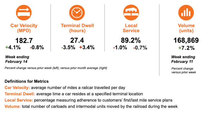
Despite this challenging environment, the operation is delivering relatively consistent overall performance while driving greater efficiencies across the network. Car velocity increased over the previous week and is close to the average levels reported last month. Local service has remained relatively stable from the previous week at nearly 90%. Terminal dwell also improved by more than 3% from the previous week. Total volume increased by more than 7% over the last week.
SERVICE EXPECTATIONS FOR THE WEEK AHEAD
Warmer temperatures in the northern region will be fleeting, as another round of Arctic cold weather will move into the Northern Plains and Upper Midwest by the end of the weekend and stay through the week. Temperatures in several North Dakota and Minnesota locations could drop to nearly 20 below zero, necessitating some train length restrictions.
Most other areas of the BNSF network will have favorable operating conditions to begin the week. A weather pattern, however, could generate scattered thunderstorms and high winds periodically across the desert Southwest and into the Plains by midweek. BNSF teams are monitoring conditions across the network and are prepared to respond quickly to any service disruptions.
As always, we thank you for your business and appreciate the opportunity to serve as your transportation service provider. We welcome your feedback and questions.